 |
|
|
‘Joining the Dots: The Historical
Appearance of “Geometric” Constellation
Figures’, research project by Anthony Auerbach.
A true Astronomer feigns
nothing without solid and sufficient Reasons, he
takes Nature for his Guide and Rule, and lays his
Foundations on Observations: He raises his System
on Physical Causes, and invincible Geometrical Demonstrations,
with which, as with an indissolvable Cement, he joins
and Binds the whole Fabrick together. [note 1]
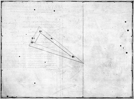
 Linking
the brightest stars with straight
lines on a map to form quasi-geometric
figures is probably the form
of the constellations most familiar
to contemporary visual culture.
Although it is widely assumed
to be the essential, the original,
even the ‘natural’ way
of drawing the constellations,
this form was not widely adopted
before the nineteenth century.
It became the norm in the twentieth
century, where constellation
figures survived, but was never
officially sanctioned [note
2]. Linking
the brightest stars with straight
lines on a map to form quasi-geometric
figures is probably the form
of the constellations most familiar
to contemporary visual culture.
Although it is widely assumed
to be the essential, the original,
even the ‘natural’ way
of drawing the constellations,
this form was not widely adopted
before the nineteenth century.
It became the norm in the twentieth
century, where constellation
figures survived, but was never
officially sanctioned [note
2].
The earliest printed map to
propose a system of ‘geometric’ constellation
figures to replace the traditional
figurative star signs appears
to be the Nouvelle
Uranographie (1786) by Alexandre
Ruelle [note 3].
Unlike other attempts at the
reform of the constellations
such as Schiller’s
Coelum Stellatum Christianum (1627)
[note 4], the Nouvelle
Uranographie was a success. As a
result, this map lost its place
in history. Whereas the various
failed attempts at reform are
still admired as historical curiosities — that
is to say, as objects without consequences — the Nouvelle
Uranographie falls into history's blind
spot.
The history of celestial cartography
is usually thought to have come to an end
at the turn of the nineteenth
century. Johann Bode’s
Uranographia (1801) is widely regarded
as the last and most magnificent
star atlas in the tradition which
reaches back to Ptolemy. Bode’s
atlas is a museum of astrography
[note 5]. It not only aggregated
the sum of observational data
and cartographic customs, but
augmented the latter with several
new constellation figures. After
Bode, the antiquarians note with
regret, star maps display either
the triumph of professional science
over the art of cartography,
or the vulgarisation of amateur
astronomy, served increasingly
with cheap, industrially produced
maps, books, gadgets and toys.
On this view, the Nouvelle Uranographie
would appear as a premature announcement
of the end of celestial cartography’s ‘golden
age’ and would thus tend to deprive the
standard history of its culmination.
Acknowledging the novelty
of the Nouvelle
Uranographie, however,
would tend to deprive subsequent
maps of the primordial authority
of ‘geometric’ figures
invoked by the promoters of
such maps (if not by historians) — those
figures which according to Galileo’s assertion
[note 6] are the characters
in which the book of the universe
is written and in which philosophy
shall be read.
Nonetheless, Ruelle’s
map is marked by the history
in which it was eventually engulfed. Having
first appeared in 1786 bearing a royal dedication,
the map’s alterations and resurfacings
(authorised or plagiarised) record
the upheavals which
revolutionised not only
the affairs of state, but also
the regime of what was soon to
become the Observatoire de la
République. By 1795, Ruelle himself
appears to have abandoned the
institution that had once been
his refuge,
‘la révolution l’ayant enlevé à l’astronomie’
[note 7].
Research will disclose the historical juncture
in which the Nouvelle Uranographie emerged — at
the convergence of astronomy
and cartography which dominated
the activities of the Paris Observatory
in the eighteenth century; at
the divergence of amateur and
professional astronomy which
came to dominate map production in the nineteenth
century; at the submergence of speculative histories
of astronomy that were discredited even as the
map’s innovation
was accepted — as well as how the writing
of history swept the map and
its author into obscurity.
Interpretation faces an anomalous object. Like
the figures which lend form to
discrete astronomical data, interpreting
the Nouvelle Uranographie will have
to deal with loose ends and disconnected
facts: with historical dead-ends.
It will risk being led by Ruelle
— whose name in French means
back alley — away from the main
street of history.
 ...
return: On cartography ...
return: On cartography
Notes
- John Keill, An Introduction
to the True Astronomy: Or,
Astronomical Lectures,
London: Bernard Lintot, 1730,
p. 27. Italics in the original. [back to text]
- The International Astronomical
Union had, at its founding in
1919, nominated the eighty-eight
constellations that would be
officially recognised and rigourously
defined by their boundaries.
The task of the scientific definition
of the constellations was entrusted
to Eugène Delporte and
published in the Délimitation
scientifique des constellations (Cambridge
University Press, 1930). The
boundaries defined on Delporte’s
map according to the geometric
division of the sphere into parallels
and meridians are the vestigial
outlines of a tradition it was
Delporte’s task both to
liquidate and to uphold. [back to text]
- Alexandre Ruelle, Nouvelle
Uranographie ou Méthode très
facile pour apprendre à connoitre
les Constellations, (Paris: Dezauche, de
la Marche et Jombert, 1786). [back to text]
- Julius Schiller, Coelum
Stellatum Christianum
(Augsburg: Andreae Apergeri, 1627). [back to text]
- Johann Elert Bode, Uranographia (Berlin: Frederico
de Haan, 1801). The atlas featured Ptolemaic
and non-Ptolemaic constellations as well as
ecliptic and equatorial graticules. The western tradition of printed maps stems
from the Renaissance. [back to text]
- Galileo Galilei, The Assayer (Garden City, NY: Doubleday, 1957), pp. 237238. [back to text]
- Jérôme de Lalande, Bibliographie astronomique avec l'histoire de l'astronomie depuis 1781 jusqu'à 1802 (Paris: Impimerie de la République, 1803), p. 596. [back to text]
Images
Triangulum from Johann Bayer, Uranometria (Augsburg, 1603)
|
|
|
|
|
|